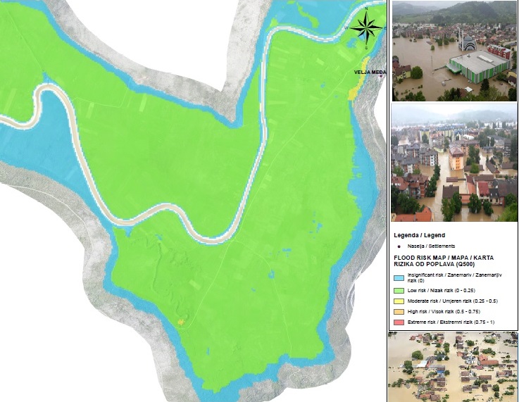
Hydro-Engineering Institute and WYG International are jointly implementing the FHRM Project in Bosnia and Herzegovina. This WBIF funded project began in March 2017 and is expected to be completed by November 2020.

The Flood Hazard and Flood Risk Maps Project in Bosnia and Herzegovina (FHRM) was one of the recovery actions recommended by the European Union, United Nations and World Bank following severe flooding in BiH in May 2014 when exceptionally heavy rain caused catastrophic floods and landslides leading to deaths and destruction and severe damage to public and private infrastructure, households, livelihoods, incomes and production. According to the BiH 2014 Flood Recovery Needs Assessment (EU, 2014) this event was the most serious natural disaster experienced in the country in the previous 120 years, affecting approximately one-third of the area of the country and more than one million people. The total economic impact of the disaster was estimated to be BAM 3.98 billion (€ 2.03 billion). Amongst the needs identified was a Disaster Risk Reduction Strategy to reduce vulnerability and make government and communities more resilient to natural disasters. This includes improvements to the prediction of river flows and climate change impacts through detailed surveys of Areas for Further Assessment (AFAs), referred to in EU Flood Directive as Areas of Significant Potential Flood Risk (ASPFRs), hydraulic modelling, and flood hazard and flood risk mapping in accordance with the EU Floods Directive (FD).
The FHRMP is executed within the Western Balkans Investment Framework (WBIF), a joint initiative of the EU, IFIs, bilateral donors and the governments of the Western Balkans, with the aim of facilitating the preparation and implementation of essential infrastructure investments in the Western Balkan countries. FHRMP is executed under the WBIF Infrastructure Project Facility 5 (IPF5) through two grants (Phase I: WB12-BIH-ENV-04C1 €3,380,000, began in December 2014; Phase II: WB19-BIH-ENV-01 €1,785,000 began in June 2018) supervised by the European Investment Bank (EIB) both as the Lead IFI and the Contracting Authority.
The FHRMP directly concerns the implementation of the FD in B&H. Its objective is in line with Bosnia and Herzegovina’s EU Integration Strategy, its membership in the International Commission for the Protection of the Danube River (ICPDR) and in the International Sava River Basin Commission (ISRBC) as well as with the national Action Plan for Flood Protection and River Management in BIH (2014-2017). In this sense, preparation of the Flood Risk and Flood Hazard Maps is a mandatory and key precondition for developing sustainable risk management plans.
In course of the Project implementation
-5,500 km2 of area were surveyed by LiDAR,
-A total of 5,253 cross-section profiles and hydraulic structures were surveyed
-136 AFAs were identified
-96 river sections (2,375 km of watercourses) were modelled to produce 93 hydraulic models for four sub-zones
-the project resulted in a total of:
- 93 depth and velocity maps
- 136 flood hazard maps
- 152 flood risk maps
Added value of the project is reflected in:
- Developed Climate Change Report with hydraulic analysis of the impact of climate change on floods
- Georeferenced database compatible with VIS (Water Information System) developed
- Data Transformation Software specially developed for the needs of the project; the software was developed by the National Space Institute at the Danish Technical University (DTU Space) as part of the post-processing activities for LiDAR data and aerial photographs. It was used to transform the raw unclassified point cloud data from its native global coordinate system to the BiH geodetic horizontal and vertical datums (MGI 1901 horizontal; NVT-I vertical) in order to overcome the existing significant differences between regional geodetic datums used in BiH and the global datum.
You can check the video of the project trough the link down bellow:
https://1drv.ms/v/s!AmeBdfLrHEGygr8fWzf3D4WAQmwQhw?e=lKeDcq